
By Scott Sistek KOMONews.com
EDITOR’S NOTE: This is from the weather blog of Port Angeles native Scott Sistek, a meteorologist who’s with the Peninsula Daily News’ news partner KOMO-TV/KOMONews.com in Seattle. Read more from Sistek at: http://www.komonews.com/weather/blogs/scott.
WE’RE COMING UP on 17 months in a row with above normal temperatures on average, and several of those months have been the warmest on record in Seattle.
This summer, we’ve had dozens of days in the 80s, already the second-most 90-degree days on record with August still to come. T
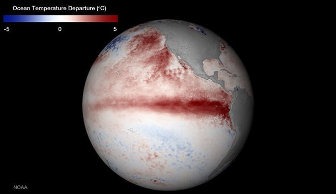
he coldest low temperature we’ve had in the entire month of July? 57. The average low is 55. People have been asking me why has it been so warm for so long? Well, NOAA did me a favor and sent out this handy graphic which shows exactly why: The warm Pacific Ocean.
The map above showing water temperatures during the week of July 13-19 and their departure from normal was intended to focus on the budding El Nino — note the classic stretch of super warm water right along the equator stretching toward South America.
Some indications are this El Nino could rival or even surpass the record El Nino of 1997-98.
But for us in the Northwest? Forget about that.
What we should focus on are the big red blobs just off the West Coast — the “Pacific Warm Blob” as many have been calling it (I’ve even started a hashtag for fellow Seattleites who miss the clouds and rain: #PacificWarmBlobMustDie).
The darkest of the red blobs indicate temperatures of 4-5 degrees above normal.
But wait, it’s even worse, because like all good global science maps, this is in the metric Celsius.
For us metric-averse Americans, that converts to 7-9 degrees F!
Think about that — water that’s normally 50-55 degrees is now pushing 60 degrees or more.
I can vouch for this. I was in Ocean Shores two weeks ago and sprained my toe. I was very eager to go dip my feet into the Pacific as like a natural ice pack, only to find the water…wasn’t really that cold. Years past, your feet would eventually go numb from the chill.
The warm blob would certainly explain our warm nighttime lows because most of the time, our weather and air flow come off the Pacific so as I mentioned in an earlier blog, it’s like sleeping next to an electric blanket that won’t turn off.
Summertime night temperatures rarely drop below 60 degrees — that’s been the case both this summer and last summer. One of the reasons why we’re on a 17-month streak of above average temperatures is largely due to warmer overnight lows that hotter daytime highs — although that’s not been a slouch.
And yes, the warm blob has affected daytime highs as well. This summer has been unique — as in perhaps a more than 1-in-100 year event — in that Seattle has had several days in the 90s without any east wind, and we can blame the blob for that too!
Normally for Seattle, the hottest we could reasonably get just on air mass alone was about 84-88 degrees.
To get above 90 degrees, we need that offshore flow where the east wind comes over the Cascades. It’s already hot and dry in Eastern Washington and when that air climbs over the Cascades, then sinks down the western slopes of the mountains, the compression of the air as it sinks causes it to warm further.
A good east wind can boost highs by 3-7 degrees around Seattle — and those are the critical degrees needed to get over 90.
Not so this year. We’ve hit 90 degrees eight times and not once have we had any kind of compressional heating boost off the Cascades.
That still has many local meteorologists shaking their heads to this day. It’s like your utility infielder is hitting .340. But it’s because the “electric blanket” of the Pacific Ocean is adding those 3-5 degrees to our high temperatures on its own.
Think of it another way, it’s like we’ve had several east wind heat waves this summer — without the east wind! It has us shuddering to think what’s going to happen if we *do* get a real east wind event this year with such a toasty ocean next door. In that sense, we’ve really dodged a bullet. Last Sunday hit 95 with no east wind. Unheard of.
What else is unheard of? A ridge of high pressure that rarely budges, and when it gives way, it only cedes its position for a short period then returns; a ridge that is an expert at a meteorological King of the Hill.
The ridge has kept storms away, which keeps the waters from churning offshore. That in turn keeps the cooler waters from the sunless depths of the oceans from being mixed to the surface… which makes the waters warmer, which helps keep the ridge in place. It’s a circle of sunlight.
It’s been more or less that way for the past 18 months, and as we’ve seen, long range climate models suggest it’s going to stay that way for the next several months.
The Pacific Ocean has gone through stretches of being warmer than normal and cooler than normal before. In fact, we were in the opposite phase in 2011 and 2012 — remember the 78 minutes of summer? The waters were quite chilly then. And even though it looks like this warm phase could last for several more months, it will eventually subside.
In the meantime, as long as the ocean stays warm offshore, the nights will end up somewhat warmer than they usually have been, and daytime high forecasts should buffer in an extra 3-4 degrees based on a typical pattern from regular summers. It also suggests this fall will remain warmer than normal, and the winter will likely have several days in the 50s again with lowland snow a significant challenge and mountain snow in short supply once again.
And there you go, as I promised in the headline, that picture was worth 1,000 words (at least according to the word counter on my word processor.)
Wait, 10 words short? I leave you with this:
#PacificWarmBlobMustDie
READ THIS IN ITS ORIGINAL FORMAT at http://www.komonews.com/weather/blogs/scott/Why-has-it-been-so-warm-so-long-This-picture-says-1000-words-318245281.html
